


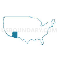
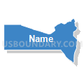
Zuni Voting District, Mohave County, Arizona
About
Outline

Summary
| Unique Area Identifier | 525008 |
| Name | Zuni Voting District |
| County | Mohave County |
| State | Arizona |
| Area (square miles) | 44.34 |
| Land Area (square miles) | 44.34 |
| Water Area (square miles) | 0.00 |
| % of Land Area | 100.00 |
| % of Water Area | 0.00 |
| Latitude of the Internal Point | 35.26850560 |
| Longtitude of the Internal Point | -114.20022580 |
Maps


Graphs
Select a template below for downloading or customizing gragh for Zuni Voting District, Mohave County, Arizona


Neighbors
Neighoring Voting District (by Name) Neighboring Voting District on the Map
- Camelback Voting District, Mohave County, AZ
- Chloride Voting District, Mohave County, AZ
- Country Club Voting District, Mohave County, AZ
- Golden Valley Voting District, Mohave County, AZ
- Sacramento Valley Voting District, Mohave County, AZ
- Southwest Kingman Voting District, Mohave County, AZ
- Verde Voting District, Mohave County, AZ